Telecom Operator

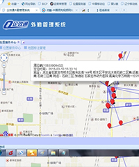
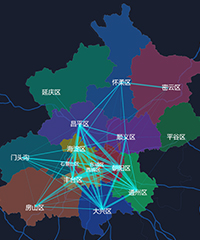
Basing on the data record  of location fusion, by using the moving speed of the user's position,    the algorithm of track point merging travel recognition and the occupational and residential characteristics of the user can be established to help operators build a better and more powerful location service platform.

 China Mobile Location Base-GIS Platform

China Mobile Location Base-GIS Platform


    Customer Requirements: China Mobile Location Base needs to provide location service capabilities and a variety of location-based services products to China Mobile's domestic branches to ensure the quality of service; while ensuring compatibility with all the original service capabilities, it also needs to launch a better performance and more powerful location service capability platform.


    Solution: Build the core location service capability platform system, including data layer, engine layer, interface layer, display layer and access layer; provide platform-oriented map, search, navigation, traffic information, satellite map, public switching, mobile map module and other LBS-based application services.


    Realizing value: Build a complete framework of LBS for China Mobile, complete WEB and client solutions, improve the service quality of China Mobile; WEB GIS solutions provide basic support for 12585 travel service application, vehicle service industry application, kinship and map service and other systems.

China Telecom Cloud-Urban Transportation Planning Subsystem

China Telecom Cloud-Urban Transportation Planning Subsystem


    Customer Requirements: Based on location fusion data records, a trajectory point merging travel recognition algorithm is established by moving speed of user's position; adjacent sectors are merged to determine the user's stopover point, and further mining and analysis are carried out with the information of stopover time, stopover purpose, number of trips, travel time and travel distance.


    Solution: Based on the fusion signaling database, the signaling data are cleaned, processed and clustered to form the location residence database; on the basis of the location residence database, the user occupational residence tracking analysis table is established by establishing the user occupational residence characteristic index, and the grid-level user OD information database is established by establishing the OD travel characteristic index.


    Realizing value: By combining the user location signaling with the complete and detailed basic attributes and telecommunication consumption data of China Telecom users, the operation situation of cities, regions and roads can be described; the analysis results can be used for population flow analysis, traffic flow analysis, etc., providing support for government decision-making, urban management planning, enterprise operation, social services, etc.


Learn how we can help

Contact Us